

Conservation, Monitoring, and Stewardship
Est. 1998

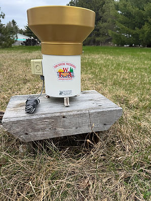
🌧️ Measuring Rainfall in Our Watershed
Through our partnership with Environment and Climate Change Canada, the TWA uses a rain gauge to measure the actual amount of precipitation received right here in the Tabusintac area.
Weather forecasts provide predictions for an area, but our rain gauge allows us to collect site-specific, real-time precipitation data. This helps us understand how much rain is actually falling in our watershed and how precipitation can vary from one location to another.
🌧️ This information is especially important as our climate changes. More intense rainfall events, changing precipitation patterns, flooding, and periods of heavy rain can all affect our waterways, wetlands, forests, and communities.
By collecting reliable local data over time, we can better understand these changes, support climate and flood-risk planning, and help inform future conservation and watershed management decisions.
Local data helps us understand local changes — and better prepare for the future. 🌿💧
Wela’lin / Thank you / Merci to our partners at Environment and Climate Change Canada for supporting local climate monitoring!